Our Work
West Michigan Trails Region
- Over 1,350 Miles of Regional Trails
- 18 Counties
- 141 Cities & Villages
- 2.2 Million People
- 22% of the Population in Michigan
- 2 MDOT Planning Regions
- 4 Michigan Planning Regions
- 6 Metropolitan Planning Organizations
Mapping Our Trail Forward: A Regional Vision
The West Michigan Regional Master Trails Plan is more than a document—it’s a living blueprint that captures the collective imagination of our community. Born from collaborative conversations among trail enthusiasts, community partners, and visionary stakeholders, this comprehensive plan represents our shared commitment to creating a dynamic network that breathes life into our regional connectivity.
Priority Projects
Lake Michigan Shoreline Trail
An ambitious vision to complete the trail along Lake Michigan’s magnificent shoreline, bridging gaps from the Indiana state line to Manistee. This isn’t just a trail—it’s a journey along one of Michigan’s most breathtaking landscapes.
West Michigan Trails is partnering with local communities, trail organizations, tourism leaders, and land managers along the West Michigan shoreline to strengthen regional trail connections and enhance the user experience.
Through collaborative planning and stakeholder engagement, partners are working to link existing trails, implement consistent wayfinding and guidance systems, and explore shared branding opportunities. This coordinated effort supports a more connected, recognizable, and accessible regional trail network for residents and visitors alike.
Central State Trail (Interurban)
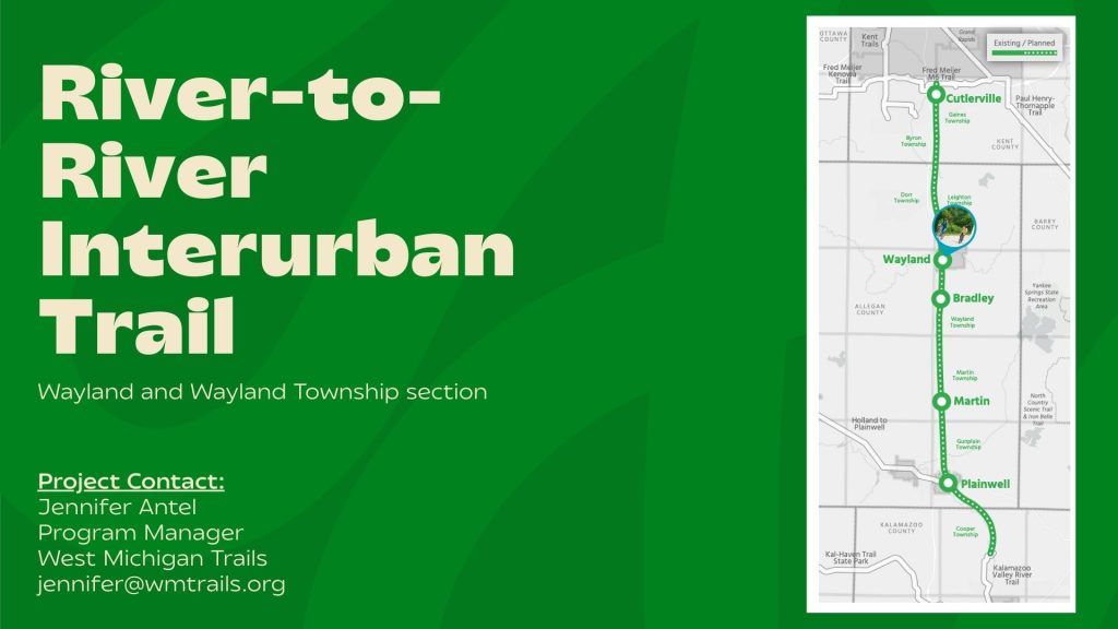
Reimagining the historic Interurban Rail Corridor from Kalamazoo to Grand Rapids, this trail will close a critical gap in our statewide trail vision. We’re not just building a path; we’re honoring our region’s transportation heritage.
In 2025 we participated in a Pitch Fest competition at the Rails-to-Trails Trail Nation Summit where we won a $10,000 grant to help further the project. A request for proposals is available HERE to conduct a route feasibility study in the City of Wayland and Wayland Township.
Find the original 2018 route feasibility below!
Once completed, this will connect the communities from Kalamazoo to Cadillac.
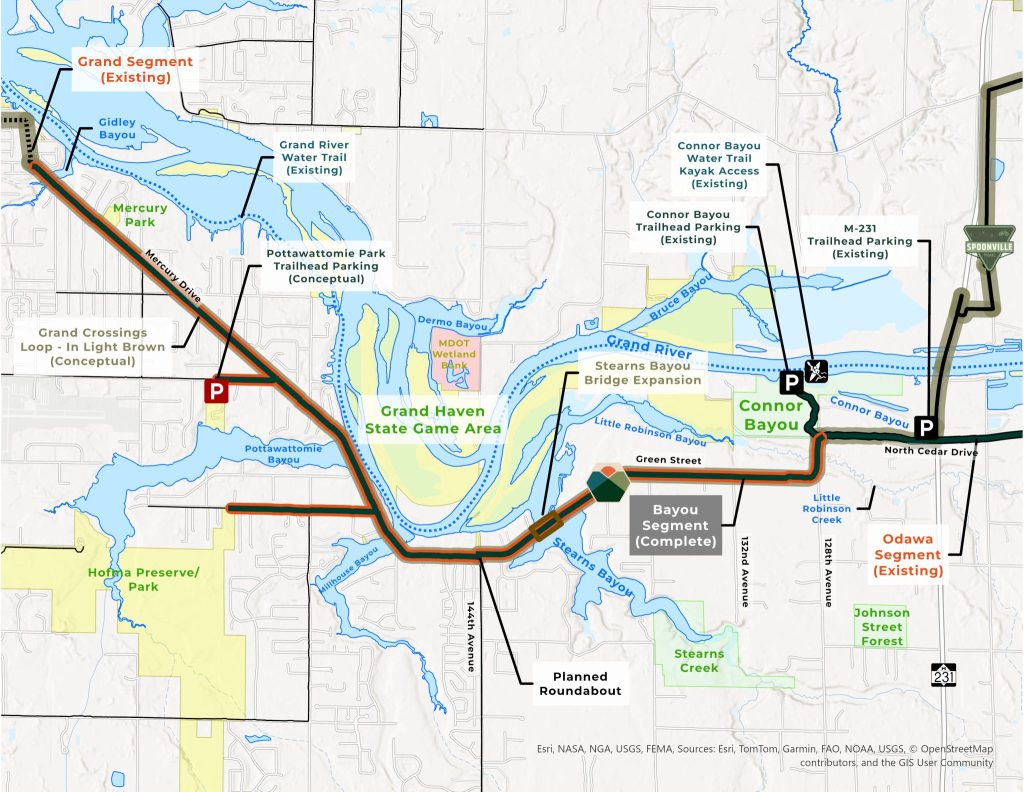
Grand River Greenway
Supporting Ottawa and Kent County’s efforts to create a continuous trail along the Grand River from Grand Haven to Grand Rapids—and beyond. The river has always been our region’s lifeline, and now our trails will celebrate that connection.
In Grand Rapids, WMT raised $686,000 to support the Grand River Edges project, a transformative trail segment that will connect downtown to over a hundred miles of regional destination trails. This isn’t just infrastructure—it’s a lifeline for safe, accessible urban exploration.
The project’s complexity is matched only by its potential. Three strategic underpasses at Ann Street, Leonard Street, and a railroad crossing will provide safe passage, while overhead lighting ensures the trail remains a welcoming space for all.
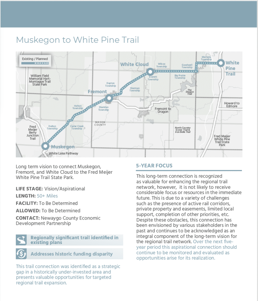
Muskegon to White Pine Connection
Closing the gap between these two communities, creating new opportunities for connection, recreation, and regional unity.
West Michigan Trails is currently working closely with local governments, landowners, trail groups, and community partners to explore and evaluate potential routes connecting Fremont and White Cloud.
Through collaborative discussion and community engagement stakeholders will identify the best path forward.
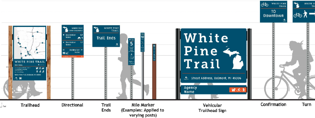
West Michigan Wayfinding Guide
WMT established a comprehensive signage system using the WMT Wayfinding Guide, ensuring every trail tells its own story and connects seamlessly to the larger network.
The Regional Wayfinding Guide is complete and ready for implementation. We are happy to help you implement the guide to help connect our trails in a whole new way. Thank you for all of the volunteers who were able to make this project possible.
Other Projects
Musketawa Trail: A Legacy Renewed
Since its first pavement in 1997, the Musketawa Trail has been a beloved regional asset. Now, we’re undertaking a crucial reconstruction project using American Rescue Plan Act (ARPA) funds. With the support of Friends of the Musketawa Trail, we’re not just repairing a path, we’re preserving a community treasure. And plans are well under-way for the reconstruction right now!
The first sections of the trail were paved in 1997 and the final segment of the 25-mile trail from Marne to Muskegon, was built in 2000. It is time for a face-lift!
The ARPA funding will cover construction of Phase 1 in the project, but matching funds are needed for the desired trail amenities including benches, fencing, wayfinding signs, and parking lot improvements. We need YOUR help! Please consider making a donation to the Friends of the Musketawa Trail to help support the project. You can donate by clicking the button below.
Follow progress coverage of the project on the states ARPA progress page: Building Michigan Together Plan – state parks progress